Showing 4845 items matching road named
-
 Federation University Historical Collection
Article - Article - Women, Ballarat College of Advanced Education: Women of Note; Dr Kiran Mazumdar-Shaw, (1953 - )
... road named... with the unveiling of a road named after her at the Mt Helen Campus. ... 2015 with the unveiling of a road named after her at the Mt ...Kiran Mazumdar-Shaw was the first and only female enrolled as a student in the brewer and biotechnologist course at BCAE In 1974. Her diligence paid off when she managed to top the class, and vital knowledge and understandings acquired during her course have subsequently contributed to other successes. On 13 December 2004 the University of Ballarat recognised Mazumdar-Shaw's pre-eminent contribution to the field of biotechnology when she was presented with an Honorary Doctorate. Dr Kiran Mazumdar-Shaw, a most distinguished alumna of the University and a pioneer of the biotechnology industry in India, was honoured by Federation University Australia on Thursday 5 March 2015 with the unveiling of a road named after her at the Mt Helen Campus. women of note, kiran mazumdar-shaw, doctor, brewer and biotechnologist, ballarat college of advanced education, honorary doctorate, 2004, biotechnology industry in india, federation university, road named, mount helen campus -
 Stawell Historical Society Inc
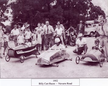
Photograph, Billy Cart Derby on the Navarre Road 1952 -- Named
... Billy Cart Derby on the Navarre Road 1952 -- Named... -- Named Billy Cart Derby - Navarre Road 1952 Stawell ...Billy Cart Derby - Navarre Road 1952stawell -
Whitehorse Historical Society Inc.
Letter - Correspondence, Letter re Arthur Schwerkolt, 2013
... Regarding changed road names and his parents' places... changed road names and his parents' places of employment... changed road names and his parents' places of employment ...Meeting between R. Whalen and Arthur Schwerkolt age.Meeting between R. Whalen and Arthur Schwerkolt regarding changed road names and his parents' places of employment, and their farm next to Schwerkolt Cottage.Meeting between R. Whalen and Arthur Schwerkolt age.schwerkolt, arthur, roads and streets, schwerkolt, myra, schwerkolt, ern -
 Ringwood and District Historical Society
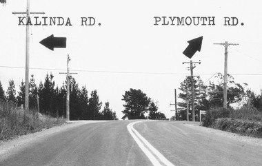
Photograph, Intersection of Kalinda Road and Plymouth Rd. Ringwood 1967
... B&W Photograph with road names and arrows added.... with road names and arrows added. Catalogue card reads ...B&W Photograph with road names and arrows added.Catalogue card reads, "Intersection of Kalinda Road and Plymouth Rd. 1967". -
Whitehorse Historical Society Inc.
Article, Fulton Family holds long district line, n.d
... Fulton Road, Blackburn was named after Andrew Fulton...., nephews of Andrew Fulton. Fulton Road, Blackburn was named after..., nephews of Andrew Fulton. Fulton Road, Blackburn was named after ...Article on the death of two elderly Fulton brothers, nephews of Andrew Fulton.Article on the death of two elderly Fulton brothers, nephews of Andrew Fulton. Fulton Road, Blackburn was named after Andrew Fulton.Article on the death of two elderly Fulton brothers, nephews of Andrew Fulton. fulton, john oliver, fulton, william oliver, fulton, andrew, fulton road, blackburn south -
Whitehorse Historical Society Inc.
Article, Love began at Mitcham factory, 2005
... McClare Road Vermont is named after Pat's grandfather who... and Gladys McClare who grew up in Mitcham. McClare Road Vermont... McClare who grew up in Mitcham. McClare Road Vermont is named ...Article about the 70th wedding anniversary of Pat and Gladys McClare who grew up in Mitcham.Article about the 70th wedding anniversary of Pat and Gladys McClare who grew up in Mitcham. McClare Road Vermont is named after Pat's grandfather who owned a tannery (Photo)Article about the 70th wedding anniversary of Pat and Gladys McClare who grew up in Mitcham. mcclare, pat, mcclare, gladys, mcclares road vermont -
Whitehorse Historical Society Inc.
Article, Carefree days last for decades, 2005
... McClares Road Vermont is named after Pat's grandfather who... and Gladys McClare who grew up in Mitcham. McClares Road Vermont... McClare who grew up in Mitcham. McClares Road Vermont is named ...Article about the 70th wedding anniversary of Pat and Gladys McClare who grew up in Mitcham.Article about the 70th wedding anniversary of Pat and Gladys McClare who grew up in Mitcham. McClares Road Vermont is named after Pat's grandfather who owned a tannery (photo)Article about the 70th wedding anniversary of Pat and Gladys McClare who grew up in Mitcham.mcclare, pat, mcclare, gladys, mcclares road vermont -
Federation University Historical Collection
Book, The Pyreness Shire, Avoca Shire Heritage Study 1864-1994, Volume 1, 1995
... - Geographical Locations of Individual Sites, alphabetically by Road Name... - Geographical Locations of Individual Sites, alphabetically by Road Name ...The Pyreness Shire, Avoca Shire Heritage Study 1864-1994, Volume 11) 21008.1 - Volume 1 - Pale blue bound book of 47 pages - Environmental History 2) 21008.2 - Volume 3 - Pale blue bound book - Geographical Locations of Individual Sites, alphabetically by Road Namewendy jacobs, karen twigg, nigel lewis/richard aitken pty ltd, shire of avoca, avoca heritage study, national estate committee (victoria), national estate grants program, victorian goldfields, pyrenees, moonambel, natte yallock, rathscar, barkly, redbank, crowlands, landsborough, the pyrenees shire, lexton shire, exploration and pastoralism, gold, water, farming, wine and fruit, towns and settlements, living in community, road and rail, extractive industries, conclusion, ballarat, major mitchell, djadja wurrung aboriginal group, djab wurrung aboriginal group, avoca, lamplough, chinese camp, alluvial mining, ironbark mine, upper homebush, homebush deep lead mine, avoca and district historical society, deep leads, quartz mining, percydale, hog's reef mine, avoca, dredging, hunter's home, moonambel c. 1890, mrs ellen allan, lamplough, the 1865 land act, flour milling, flour mill, moonambel. c. 1880, harkins farm, bung bong c. 1900, dairying, viticulture, navarre, schools, churches, cemetaries, wars, hotels, halls, sports, horse racing, country fire authority, maryborough-avoca railway, cobb and co -
Whitehorse Historical Society Inc.
Map, Parish of Nunawading, 1892
... Lithographed by G.S. Bonne[y]. Map includes roads... roads, railway, stations, names of property owners. 2nd copy... by G.S. Bonne[y]. Map includes roads, railway, stations, names ...Map copied from 'Directory maps - parishes and counties' 26 Nov 1892.Map copied from 'Directory maps - parishes and counties' 26 Nov 1892. Lithographed by G.S. Bonne[y]. Map includes roads, railway, stations, names of property owners. 2nd copy 'for copying'.Map copied from 'Directory maps - parishes and counties' 26 Nov 1892. maps, parish of nunawading -
Whitehorse Historical Society Inc.
Map, This is Vermont, 1895-1920?
... to Heatherdale Road, showing the names of owners of houses, main roads... the names of owners of houses, main roads and streets, shops... Road to Heatherdale Road, showing the names of owners of houses ...'Now you have seen it, tell your friends''Now you have seen it, tell your friends' - hand-drawn map of Vermont from Springvale Road to Heatherdale Road, showing the names of owners of houses, main roads and streets, shops and schools.'Now you have seen it, tell your friends' vermont south, vermont, roads and streets -
 Peterborough History Group
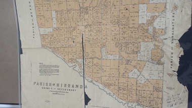
Map - Map of the Parish of Nirranda, Parish of Nirranda
... Map of the Parish including roads, names of landowners... including roads, names of landowners, location of schools etc ...Map of the Parish including roads, names of landowners, location of schools etc in 1939A3 size map of the Parish of Nirranda in 1939nirranda, maps, parish map -
 Melbourne Tram Museum
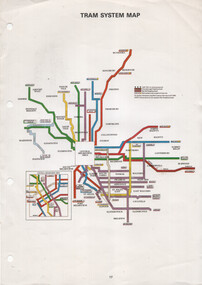
Map, The Met, "Tram System Map", c1990
... Melbourne tram routes, route numbers, principal road names, suburbs... tram routes, route numbers, principal road names, suburbs ...Tram system map published by The Met to show the various Melbourne tram routes, route numbers, principal road names, suburbs and tram routes within the Central Business District.Provides information about Melbourne tram routes c1990Printed A4 full colour sheet with four punch holes on left hand side.tramways, melbourne, the met, map, tram routes, routes -
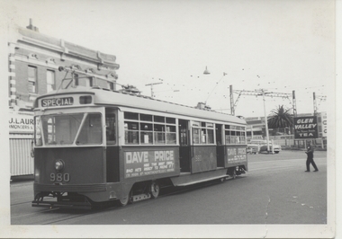 Melbourne Tram Museum
Photograph - Black & White Photograph/s, Chris Phillips, Feb. 1969
... Melbourne depot. Road name to be advised. Printed on Kodak... of the tram. ARE Tour ex South Melbourne depot. Road name ...Black and white photograph of PCC 980 at Caulfield Station area, during a special tram tour, 9/2/1969. Photo by Chris Phillips. Glen Valley Tea advert in background. Has a Dave Price advertisement on the side of the tram. ARE Tour ex South Melbourne depot. Road name to be advised. Printed on Kodak Paper.In red ink "PCC 980 Caulfield Stn 9/2/69"trams, tramways, mmtb, special trams, caulfield, tram 980, pcc class -
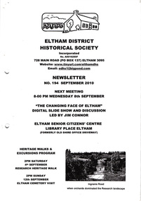 Eltham District Historical Society Inc
Newsletter, No. 194 September 2010
... Names; The North-South Roads • More News ... Read’s Early History • Local Road Names; The North-South Roads ...Contents: • Next meeting, Slide Show and Discussion led by Jim Connor: The Changing Face of Eltham • September Meeting • Research Heritage Walk • Eltham Cemetery Visit • Distinguished Life Members by Jim Connor • Jock Read’s Early History • Local Road Names; The North-South Roads • More News The Shire of Eltham Historical Society was formed in October 1967. The first newsletter of the Society was issued May 1978 and has been published continuously ever since on a bi-monthly basis. With the cessation of the Shire of Eltham in late 1994, the Society's name was revised to Eltham District Historical Society and this name first appeared with issue No. 103, July 1995. The collection of the Society's newsletters provides a valuable resource on the history of the Society's activities, office bearers and committee members, guest speakers and subjects of historical interest pertinent to the former Shire of Eltham and the Eltham District.A4 photocopied newsletter distributed to membersnewsletter, eltham district historical society, shire of eltham historical society -
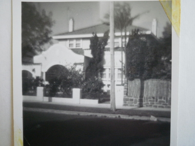 Glen Eira Historical Society
Photograph - St. Georges Road, 36, Elsternwick
... St. Georges Road, Elsternwick, named Aloha.... St. Georges Road, Elsternwick, named Aloha. Photographs House ...A black and white photograph, undated, of the house at 36 St. Georges Road, Elsternwick, named Aloha.photographs, house names, st. georges road, aloha, elsternwick, houses -
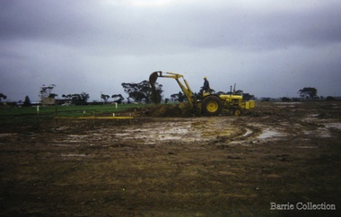 Melton City Libraries
Photograph, Building a new school, 1974
... School opened its doors. Coburn Road named after Coburns, early... doors. Coburn Road named after Coburns, early settlers family ...There were no high schools in the area pre 1975, and students from Melton, Melton South and Toolern Vale State Schools went by bus to Bacchus Marsh High School. In 1975, Melton High School opened its doors. Coburn Road named after Coburns, early settlers family and George Coburn Councillor and 1935 Shire PresidentEarth works undertaken for the development of Melton High School, Coburns Road, Melton Westeducation -
 Warrnambool and District Historical Society Inc.
Financial record - Ledger, Warrnambool Shire Council 1899-1918, Circa 1900
... for roads. Names of places and structures include Dennington Bridge..., complaints, applications for roads. Names of places and structures ...Provides a collection of letters to the President and Councillors of the Shire of Warrnambool from J. M. Crawley. The period covered is 1900 to 1918. It covers such topics as repairs to bridges, purchasing of equipment, complaints, applications for roads. Names of places and structures include Dennington Bridge, Cassidy’s Bridge, Warrumyea Bridge, Yangery, Purnim. Loose within the book is a letter from a W,M(H?) Clarke of Garvoc. The letters contained in this ledger provide information on a large range of works which were carried out in the Shire in the early 1900’sDark olive green fabric cover with tan spine and cornersMinute Book in gold lettering on red background on spine.warrnambool shire council 1899-1918, crawley j w crawley, warrnambool shire offices, warrnambool -
Whitehorse Historical Society Inc.
Letter - Correspondence, Janice Rooks, 2016
... and McClares Roads, Vermont were named after her Great-grandparents....Whitehorse Historical Society Inc. 2-10 Deep Creek Road ...A letter from Janice Rooks describing how Rooks and McClares Roads, Vermont were named after her Great-grandparents.A letter from Janice Rooks describing how Rooks and McClares Roads, Vermont were named after her Great-grandparents.A letter from Janice Rooks describing how Rooks and McClares Roads, Vermont were named after her Great-grandparents.rooks, janice, vermont state school no 1022, rooks, charles mayor, mcclare, mcclares road, vermont, charles rooks reserve, rooks road, vermont -
 Kew Historical Society Inc
Plan - Subdivision Plan, Lodged Plan No.6518, 1920-1940
... of street names. Argyle Road in the centre of the subdivision... a challenge due to a change of street names. Argyle Road in the centre ...The Kew Historical Society collection includes almost 100 subdivision plans pertaining to suburbs of the City of Melbourne. Most of these are of Kew, Kew East or Studley Park, although a smaller number are plans of Camberwell, Deepdene, Balwyn and Hawthorn. It is believed that the majority of the plans were gifted to the Society by persons connected with the real estate firm - J. R. Mathers and McMillan, 136 Cotham Road, Kew. The Plans in the collection are rarely in pristine form, being working plans on which the agent would write notes and record lots sold and the prices of these. The subdivision plans are historically significant examples of the growth of urban Melbourne from the beginning of the 20th Century up until the 1980s. A number of the plans are double-sided and often include a photograph on the reverse. Reconciling this hand-drawn subdivision plan with a modern map of the area is initially a challenge due to a change of street names. Argyle Road in the centre of the subdivision was to be renamed Deepdene Road, and the street named Deepdene Road on the plan was to become Deepdene Place. Of interest is the nursery on the corner of Argyle and Whitehorse Roads. During this period there were a number of nurseries servicing the Kew and Balwyn areas. The subdivision was essentially of the land formerly occupied by the house 'Deepdene'.subdivision plans - balwyn, deepdene, whitehorse road -- deepdene (vic.), deepdene road -- deepdene (vic.), burke road -- deepdene (vic.) -
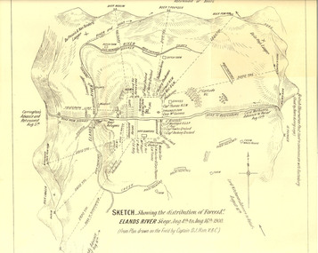 Federation University Historical Collection
Plan, Sketch of Elands River Siege, 1900
... River siege. Map details surrounding hills, roads, rivers..., roads, rivers, and names all soldiers involved in siege. Plan ...Plan based on the field notes of Captain David John Ham, V.B.C. For article written by Ham on the event, see http://trove.nla.gov.au/ndp/del/article/9542500 For obituary of Ham, see http://trove.nla.gov.au/ndp/del/article/11023251Sketched paper map of forces' distribution at the Elands River siege. Map details surrounding hills, roads, rivers, and names all soldiers involved in siege. boer war, map, sketch, victorian's bushmen contingent, hocking, fowles, methuens, david john ham -
 Whitehorse Historical Society Inc.
Photograph, Bill Cook
... named after him. Cook Street (Cook Road) formed the Western... photo of Bill Cook. Cook Road in Mitcham named after him. Cook ...Black and white photo of Bill Cook. Cook Road in Mitcham named after him. Cook Street (Cook Road) formed the Western Boundary of his orchard in Mitcham.cook, bill, cook road, mitcham -
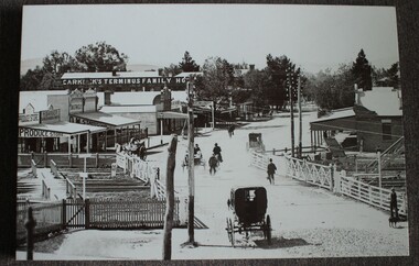 Wodonga & District Historical Society Inc
Photograph - Carkeek's Terminus Family Hotel, Wodonga, c1890
... includes Carkeek's Terminus Family Hotel in Sydney Road, now named... Hotel in Sydney Road, now named High Street, Wodonga, Victoria ...The Terminus Hotel, Wodonga was built by James Thompson Hatch in 1873, the same year the railway reached Wodonga from Melbourne. It was named due to its close proximity to the railway terminus. It was sold to Messrs George Day and Kenneth McLennan of Albury. It was first licenced to J.G. Morton in January 1874. Annie Allen, from Ireland, took over as licensee of the hotel containing 14 rooms in 1879, after she and her husband, George James Allen, purchased it. In 1887 they added a new wing on the south boundary of the property next to Peter McLean’s store at 81 Sydney Road. The architects for the new wing were Gordon and Gordon. A billiard room, a dining room, and 18 other rooms were added on the vacant block of land between the Hotel and the Bank of Victoria. A balcony 6 feet wide was added on the north side. Included in the plans was the latest patent elevator, later known as a dumb waiter. Allen died in 1889 aged 52, and Annie Allen continued to run the Terminus. She later married John G. Haldon and was licensee of the hotel until December 1898 when the licence was transferred to William Carkeek. Carkeek, from Cornwall, arrived in the colony around 1860 and is considered one of the founders of Tallangatta. In November 1903, the license was transferred to Daniel Crawford, then in 1906 it was transferred to Mr Stephen Carkeek. In 1916 it passed into the hands of Mr H. W. Allen of Rutherglen, son of Mr George James Allen. On 1st June 1998 the Terminus Hotel was destroyed by fire. Estimates of damage range from between a conservative $750,000 to as high as $2 million. The remains of the building were demolished in 1999.The Terminus Hotel was one of the earliest hotels in Wodonga with clear links to the establishment of the railway line. It was an important business and meeting place for social gatherings.A black and white image printed on canvas. The image includes Carkeek's Terminus Family Hotel in Sydney Road, now named High Street, Wodonga, Victoria. Other businesses shown include a produce store, D.M. Staveley Taylor, John Whan General Store. The railway track can be seen in the foregrounc.Across side of building "CARKEEK'S TERMINUS FAMILY HOTEL" On bottom left "High Street Wodonga 1890s"carkeek, terminus hotel, hotels wodonga -
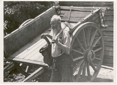
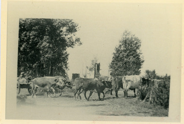 Mt Dandenong & District Historical Society Inc.
Photograph, Sim Kent's Bullocks at Coonara Springs, 1911
... paddock in Mernda Road at Coonara Springs after which the road... after which the road is now named. Sim Kent bullocks Coonara ...Photograph showing Sim Kent's bullocks at Coonara Springs in 1911. The descriptive text on the reverse of this photograph was hand written by John Lundy-Clarke. 1911 Sim Kent’s bullock team turning into their home paddock in Mernda Road at Coonara Springs after which the road is now named. sim kent, bullocks, coonara springs, mernda road, coonara road, olinda -
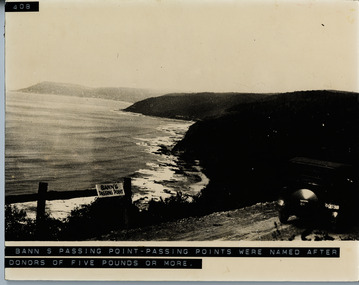 Lorne Historical Society
Photograph, Bann's Passing Point
... G.O.R Car at passing point (note sheer edge of road... Parade Lorne great-ocean-road Photograph Photograph Bann's ...G.O.R Car at passing point (note sheer edge of road) Passing Point was named after donors of 5 pounds or moreg.o.r.: bann's passing point: doner acknowledgements: -
 Kew Historical Society Inc
Plan - Subdivision Plan, J R Mathers & McMillan, Plan of Subdivision of Part of Crown Portion 83 at Kew : LP6669, 1923-1939
... starting point for the surveyors, but the Road named ‘Street Street... starting point for the surveyors, but the Road named ‘Street Street ...In 1888, in the section of Park Hill Road between Belmont Avenue and Normanby Road there was only one street running between Park Hill Road and Cotham Road. This was Park Road, later to be named Adeney Avenue. Subsequent 20th century subdivisions created the ‘through roads’ of Cecil Street, Wimba Avenue, Florence Avenue, Marshall Avenue, Uvadale Road, and Barrington Avenue. This subdivision represents an attempt by auctioneers, rather than town planners to create an urban environment from larger residential allotments or in many cases farmland. Existing streets such as Parkhill and Normanby Roads provided a convenient starting point for the surveyors, but the Road named ‘Street Street’ indicates the role of the private surveyor in creating streets. Given that a number of allotments are listed as sold on the plan, the street is presumably Cecil Street. Even those lots that had been sold do not quite match the dimensions of the blocks in this parcel of land today, indicating that either further subdivisions or boundary alterations occurred.Subdivision plans are historically important documents used as evidence for the growth of suburbs in Australia. They frequently provide information about when the land was sold as well as evidence relating to surveyors and real estate and financial agents. The numerous subdivision plans in the Kew Historical Society's collection represent working documents, ranging from the initial sketches made in planning a subdivision to printed plans on which auctioneers or agents listed the prices for which individual lots were sold. In a number of cases, the reverse of a subdivision plan in the collection includes a photograph of a house that was also for sale by the agent. These photographs provide significant heritage information relating house design and decoration, fencing and household gardens.The photograph may also be aesthetically significant depending on the importance of the photographic atelier.Hand-drawn subdivision plan of 19 lots facing Parkhill Road, Normanby Road, and an unnamed street [now Cecil Street] in Kew.Estate Agent notes in ink indicate those lots which had sold.subdivision plans - kew, parkhill road - kew, cecil street - kew, normanby road - kew, cecil street -kew, parkhill road - kew, normanby road - kew, crown portion 83 - kew -
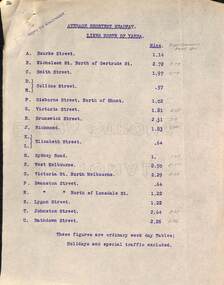 Melbourne Tram Museum
Document - Report, Tramway Board, "Average Shortest Headway lines north and south of the Yarra", c1916 to 1920
... up in red with numbers and the road names. Not understood... up in red with numbers and the road names. Not understood ...Set of typed sheets and map: .1 - carbon copy on quarto paper titled "Average Shortest Headway lines north of Yarra", giving the average headway for each street, route, eg Collins St, .57mins and for West Melbourne 8.5mins. Has in pencil alongside in pencil, the times for "Royal Commission Report 1911" .2 - ditto "Average Shortest Headway lines south of Yarra" Has a note that these numbers were for ordinary weekday tables, holidays and special traffic excluded. .3 - Map - accompanied these reports, titled "Map showing tramway Lines", which has been marked up in red with numbers and the road names. Not understood what the numbers mean, could be a reference to a report numbering. All documents undated, c 1916 to 1920.1 - has stamp "Copy to Engineer" in top left hand corner.trams, tramways, cable trams, reports, services, map, mto co, royal commission, timetables -
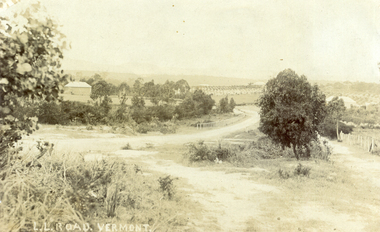 Whitehorse Historical Society Inc.
Photograph, L L Road Vermont, late 1800
... after which the road was named. Name was changed to Boronia Road.... The property was known as L L Vale after which the road was named. Name ...Dr L L Smith was a pioneer of the Vermont District. He owned 250 acres in the area bounded by Boronia, Canterbury and Heatherdale Roads and the creek. The property was known as L L Vale after which the road was named. Name was changed to Boronia Road in later years. He was a Doctor with rooms in the City, was a member of Parliament.Sepia Postcard of L L Road, Vermont (now Boronia Road) taken in the early 1900s (card is postmarked 27 Aug 1909). Shows the road going down it is presumed to the creek. It is possible that the house is that of Dr.L.L.Smith. See History.|Orchard in background is the Finger orchard. (from Mr. Shambrook - Tim's father)|Information on the back of the Postcard reveal it was sent to Miss Roberts of 61 Hoddle Street Richmond Victoria by Muriel at 37 Victoria Road Northcote and was posted at the Fairfield Post Office Victoria on 27 August 1909. Text is 'Dear Ethel Just a Post Card to let you know I will be out to see you on Monday if convenient. I came down with Mr Hutchinson and he asked me what were we laughing out on the Sunday when he came up. Muriel|See the following references -ND199, 313, 539. 1242, 2013, 3680 & 4295.l l road vermont, boronia road vermont, smith . l l dr -
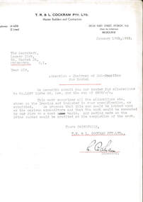 Melbourne Legacy
Letter, Alterations to 1267 Burke Road
... Club submitting their tender for alterations to 1267 Burke Road.... The property mentioned at 1267 Burke Road was named Holmbush ...A letter dated 18 January 1943 from builders to the Legacy Club submitting their tender for alterations to 1267 Burke Road for the sum of £408. The property mentioned at 1267 Burke Road was named Holmbush and was the first hostel for children that Legacy started and operated from April 1943. It was later renamed Blamey House after another hostel called Blamey House was closed.A record of the tender process to make changes to Holmbush to become a residence for children.White quarto letterhead, black type, two hole punched, a letter about alterations to be made at Holmbush.Signed in ink by L. Cockram of T.R. and L. Cockram Pty Ltd, Master Builders and Contractorsresidences, renovations, holmbush -
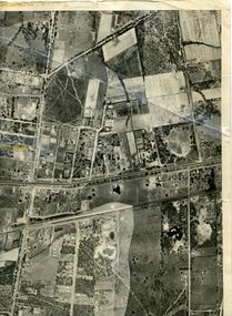 Whitehorse Historical Society Inc.
Map, Photo-map Ringwood A4A, 1945
... (North to south). Names of main roads inscribed....) and Springfield Road to Hawthorn Road (North to south). Names of main ...Aerial photo covering approximately from Box Hill to Mitcham (West to East) and Springfield Road to Hawthorn Road (North to south).Aerial photo covering approximately from Box Hill to Mitcham (West to East) and Springfield Road to Hawthorn Road (North to south). Names of main roads inscribed.Aerial photo covering approximately from Box Hill to Mitcham (West to East) and Springfield Road to Hawthorn Road (North to south).aerial photographs, box hill, blackburn, nunawading, forest hill, mitcham -
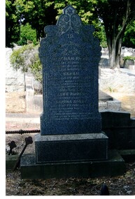 Whitehorse Historical Society Inc.
Photograph, Tombstone - Rooks family
... a school was attached to the chapel. Rooks Road is named after him.... to the chapel. Rooks Road is named after him. Rooks Abraham Rooks Sarah ...The Rooks family emigrated from England in 1857. Abraham Rooks came to Forest Hill in 1862 and leased 79 acres. After 10 years of successful farming he owned the land. Abraham Rooks held the first church meetings in his home and in 1865 was one of the trustees to receive a crown grant to erect a chapel. In 1970 a school was attached to the chapel. Rooks Road is named after him.Coloured photo of the Rooks family tombstone - grave 226, Methodist section|Rooks, Abraham died 1 September 1889, aged 65 years|Rooks, Sarah died 2 January 1898, aged 66 yearsrooks, abraham, rooks, sarah, tombstones, rooks road, vermont